Price
[[listData.currency]][[listData.discount_price]]
[[listData.currency]][[listData.price]]
save [[parseInt((1-listData.discount)*100) ]]%
[[listData.product_sku.sku_code.show_name]]
more
retract
Please select
[[listData.product_sku.sku_code_add.show_name]]
[[listData.product_sku.sku_code_add.show_name]]
ADD TO CART
BUY NOW
ADD TO
CART
BUY NOW
Unlock Exclusive Deals Now!
Limited-time special prices shop your favorites before they're gone! Click below to start saving!
Go to
see
[[num_page_4]]
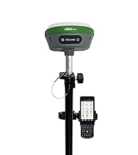
NOAA-Certificated 1cm Accurate GPS RTK Survey Equipment, 1408-Channel R26 V2
$
469.00
$328.30
Selected product:
[[dectitle]]
more
retract
Please select
[[pageData.product_sku.sku_code_add.show_name]]
[[pageData.product_sku.sku_code_add.show_name]]
ADD TO CART
ADD TO
CART
GNSS RTK Rover, Base, and Collector
Key Features
- GNSS RTK Accuracy: Achieve 1cm RTK accuracy with advanced full-frequency and full-constellation support.
- Communication Range: Ensure reliable communication within a 5-10km UHF distance between rover and base.
- Tilt Measurement Precision: Measure angles between 30°-60° with centimeter accuracy for precise positioning.
- Battery Life: Enjoy up to 2 working days with each charge, offering significant operational flexibility.
- Post-Processing Precision: Achieve better than 10cm accuracy using PPP methods, no base station required.
U.S. Certification and Data Formats
- NOAA Certified: The SMA26 antenna is certificated by NOAA, compatible with US National spatial reference systems.
- Data Output Formats: Support RTCM3.X, NMEA-0183, and binary formats, with the ability to convert to RINEX.
- PPP Method: Provided by Galileo HAS corrections for high-precision measurements.
Connection Options
- Connection Methods: Connect via Bluetooth, WiFi, or USB Type-C. TNC Connector and Serial Port (DB9 cable optional) are also available.
Compatibility and Versatility
- Multiple Constellations: Adapt to any country with support for GPS L1, L2, L5, GLONASS, BDS, and Galileo.
- Challenging Environments: Designed for use in complex and challenging environments.
RTK Connection
- Rover+Base: Connect the collector to the GNSS receiver via WiFi on the WEBUI or Bluetooth to set the rover and base at the same protocol and frequency.
- Rover+CORS: Log into CORS accounts to achieve RTK fixed positioning.
Applications
- Surveying and Engineering: Ideal for topographic, geographic, engineering, agricultural, mining, construction, and hydrographic surveying.
Functions
- Built-in Features: Wheeled GNSS receiver with wireless connectivity, storage, positioning, and inertial navigation modules for diverse land surveying requirements.
- Professional Software: The collector includes a professional surveying software for high precision, low power consumption, and easy portability and operation.
- BaseStation and Rover: Together, these achieve centimeter-level precision measurements.
RTK Software
- Pre-installed: The RTK surveying software is pre-installed and permanently valid on the handheld collector.
- Software Updates: Always have access to the latest version through a download link, ensuring the latest features and improvements.
Technical Support
- Customer Support: Contact the seller's tech team via email for any issues. Refer to the PDF e-manual and operation videos for guidance.


